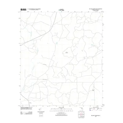
2012 Map of Mallory Swamp NW
USGS Topo · Published 2012About this map
The Steinhatchee River defines the western edge of this landscape, its path cutting through the lowlands of Lafayette County before reaching the dense wetland expanse of Mallory Swamp. In the early 21st century, this area remains characterized by isolated hunting camps and named rises in the terrain that provided firm ground amidst the wetlands. Easter Hole Camp sits in the southwest, while named landmarks like Brushy Hammock and Driggers Ridge highlight the subtle elevations critical to navigating this riverine environment. The transport network consists of specialized local routes including Long Trestle Rd and Henry Land Bend Rd, reflecting the historical timber and hunting interests of the region. Small water bodies like White Pond and Bird Pond dot the eastern interior, providing further points of reference in a territory defined by its complex hydrography.
Find a feature on this map
11 named features on this map. Tap any name to fly to it.
Don’t see what you’re looking for? This feature index may not catch every label — zoom into the map to look around manually.
Map Details
Editions of this 2012 Mallory Swamp NW Map
This is the sole edition of this map. No revisions or reprints were ever made.
Other maps of this area

1954 · Mallory Swamp NW
USGS Topo · 1:24,000

1954 · Day SE
USGS Topo · 1:24,000

1954 · Clara
USGS Topo · 1:24,000

1954 · Mallory Swamp SW
USGS Topo · 1:24,000

1954 · Cooks Hammock
USGS Topo · 1:24,000

1954 · Mallory Swamp SE
USGS Topo · 1:24,000

1954 · Mallory Swamp NE
USGS Topo · 1:24,000

1954 · Gainesville
USGS Topo · 1:250,000

1954 · Valdosta
USGS Topo · 1:250,000

1955 · Mayo
USGS Topo · 1:24,000