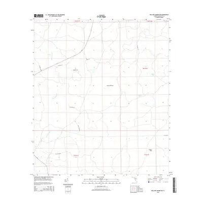
2015 Map of Mallory Swamp NW
USGS Topo · Published 2015About this map
The Steinhatchee River winds through this section of Lafayette County, defining a landscape of low-lying wetlands and subtle elevations. This 2015 survey illustrates a primarily rural environment where transport is facilitated by a network of logging and local roads, including Long Trestle Rd and Se N Canal Rd, which cut through the dense vegetation. Small water bodies like White Pond and Bird Pond dot the terrain, while the naming of Brushy Hammock and Driggers Ridge indicates slightly higher, drier ground amidst the surrounding swampy conditions. The presence of S Sr 51 and CR 357 shows the modern infrastructure connecting these remote parts of the Florida interior, where historical land divisions from the Public Land Survey System remain the primary organizing feature of the territory.
Find a feature on this map
22 named features on this map. Tap any name to fly to it.
Don’t see what you’re looking for? This feature index may not catch every label — zoom into the map to look around manually.
Map Details
Editions of this 2015 Mallory Swamp NW Map
This is the sole edition of this map. No revisions or reprints were ever made.
Other maps of this area

1954 · Mallory Swamp NW
USGS Topo · 1:24,000

1954 · Day SE
USGS Topo · 1:24,000

1954 · Clara
USGS Topo · 1:24,000

1954 · Mallory Swamp SW
USGS Topo · 1:24,000

1954 · Cooks Hammock
USGS Topo · 1:24,000

1954 · Mallory Swamp SE
USGS Topo · 1:24,000

1954 · Mallory Swamp NE
USGS Topo · 1:24,000

1954 · Gainesville
USGS Topo · 1:250,000

1954 · Valdosta
USGS Topo · 1:250,000

1955 · Mayo
USGS Topo · 1:24,000