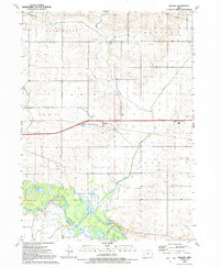
1991 Map of Malone
USGS Topo · Published 1992About this map
Malone serves as the central hub of this eastern Iowa landscape, situated just north of the winding Wapsipinicon River. The map captures a transition between the organized agriculture of De Witt and Eden townships and the complex marshlands of the river basin. Genealogists will find significant value in the numerous burial sites documented across the countryside, including the Pelham Cem, Cousin-Smith Cem, and the uniquely named Bowers-Dannatt-Hill Cem.
Find a feature on this map
22 named features on this map. Tap any name to fly to it.
Don’t see what you’re looking for? This feature index may not catch every label — zoom into the map to look around manually.
Map Details
Editions of this 1991 Malone Map
This is the sole edition of this map. No revisions or reprints were ever made.
Other maps of this area

1891 · DeWitt
USGS Topo · 1:62,500

1891 · Davenport
USGS Topo · 1:62,500

1892 · Goose Lake
USGS Topo · 1:62,500

1892 · Leclaire
USGS Topo · 1:62,500

1893 · Leclaire
USGS Topo · 1:62,500

1894 · Goose Lake
USGS Topo · 1:62,500

1894 · Davenport
USGS Topo · 1:62,500

1899 · Clinton
USGS Topo · 1:125,000

1901 · Rock Island
USGS Topo · 1:125,000

1910 · Rock Island
USGS Topo · 1:125,000