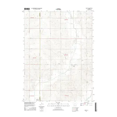
2015 Map of Maloy
USGS Topo · Published 2015About this map
Maloy sits at the heart of this Southern Iowa landscape, where the meandering course of the Platte River defines the drainage patterns of both Taylor and Ringgold counties. This agricultural region is marked by a network of sectional roads like Yellowstone Ave and Tay-Gold Ave, which connect isolated homesteads to the small village centers. Family and local history is preserved at several rural burial grounds, including Platte River Cem and Saint Marys Cem near the town center, as well as Forest Home Cem to the south. Further south, the edge of Blockton appears, situated near the headwaters of the Grand River. The map illustrates a classic Midwestern survey grid, where high-elevation ridges separate the river valleys, and road names often change as they cross the county line between Taylor and Ringgold counties.
Find a feature on this map
31 named features on this map. Tap any name to fly to it.
Don’t see what you’re looking for? This feature index may not catch every label — zoom into the map to look around manually.
Map Details
Editions of this 2015 Maloy Map
This is the sole edition of this map. No revisions or reprints were ever made.
Other maps of this area

1940 · Blockton
USGS Topo · 1:62,500

1940 · Bedford
USGS Topo · 1:62,500

1943 · Bedford
USGS Topo · 1:62,500

1943 · Blockton
USGS Topo · 1:62,500

1955 · Nebraska City
USGS Topo · 1:250,000

1957 · Nebraska City
USGS Topo · 1:250,000

1958 · Nebraska City
USGS Topo · 1:250,000

1980 · Merle Junction
USGS Topo · 1:24,000
1980 · Conway
USGS Topo · 1:24,000
1980 · Sheridan
USGS Topo · 1:24,000