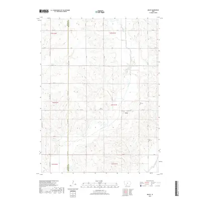
2018 Map of Maloy
USGS Topo · Published 2018About this map
Maloy sits at the heart of this rural landscape, positioned just east of the Taylor County and Ringgold County border. The area is defined by a dense network of rolling drainage patterns, where the Platte River and its tributaries like Platte Br and Turkey Cr have carved the terrain into a series of ridges and valleys. Small community landmarks reflect the local genealogy and settlement history, including the Platte River Cem and Saint Marys Cem located near the town site. In the southeast, the Grand River appears briefly, marking the reach of another major watershed. The map reveals a strictly organized grid of rural roads, such as Co RD j35 and Yellowstone Ave, which navigate the elevation changes to connect the dispersed farmsteads characteristic of this part of southern Iowa.
Find a feature on this map
33 named features on this map. Tap any name to fly to it.
Don’t see what you’re looking for? This feature index may not catch every label — zoom into the map to look around manually.
Map Details
Editions of this 2018 Maloy Map
This is the sole edition of this map. No revisions or reprints were ever made.
Other maps of this area

1940 · Blockton
USGS Topo · 1:62,500

1940 · Bedford
USGS Topo · 1:62,500

1943 · Bedford
USGS Topo · 1:62,500

1943 · Blockton
USGS Topo · 1:62,500

1955 · Nebraska City
USGS Topo · 1:250,000

1957 · Nebraska City
USGS Topo · 1:250,000

1958 · Nebraska City
USGS Topo · 1:250,000

1980 · Merle Junction
USGS Topo · 1:24,000
1980 · Conway
USGS Topo · 1:24,000
1980 · Sheridan
USGS Topo · 1:24,000