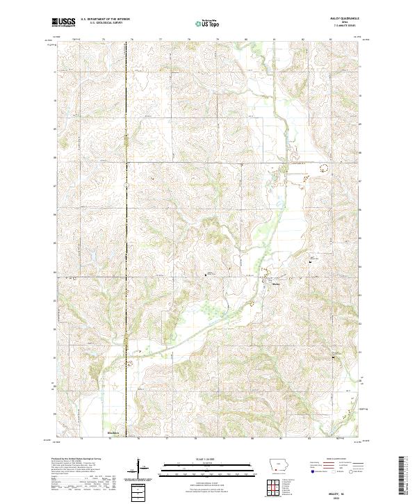
2022 Map of Maloy
USGS Topo · Published 2022About this map
The Platte River meanders through the heart of this agricultural landscape in southwest Iowa, marking a distinct boundary between the townships of Taylor and Ringgold counties. This region is characterized by its organized grid of section lines and country roads, where small communities like Maloy and the northern edge of Blockton serve as local anchors. The map reveals several significant burial sites that provide a link to the area's early settlement history, including Saint Marys Cem, Platte River Cem, and Forrest Home Cem situated near the county line. The drainage of the land is defined by numerous smaller waterways such as Platte Br and Turkey Cr, which eventually feed into the broader basin of the Grand River at the southern edge. The distribution of these landmarks reflects a stable rural pattern of small-town centers and quiet cemeteries serving the surrounding family farms.
Find a feature on this map
41 named features on this map. Tap any name to fly to it.
Don’t see what you’re looking for? This feature index may not catch every label — zoom into the map to look around manually.
Map Details
Editions of this 2022 Maloy Map
This is the sole edition of this map. No revisions or reprints were ever made.
Other maps of this area

1940 · Blockton
USGS Topo · 1:62,500

1940 · Bedford
USGS Topo · 1:62,500

1943 · Bedford
USGS Topo · 1:62,500

1943 · Blockton
USGS Topo · 1:62,500

1955 · Nebraska City
USGS Topo · 1:250,000

1957 · Nebraska City
USGS Topo · 1:250,000

1958 · Nebraska City
USGS Topo · 1:250,000

1980 · Merle Junction
USGS Topo · 1:24,000
1980 · Conway
USGS Topo · 1:24,000
1980 · Sheridan
USGS Topo · 1:24,000