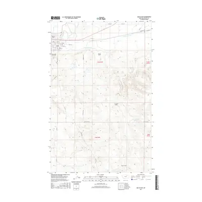
2017 Map of Malta East
USGS Topo · Published 2017About this map
Malta serves as the primary hub in this portion of Phillips County, situated where the northern plains meet the vital water systems of the Milk River. The town's layout is clearly defined by a residential grid, including streets like S 2nd St E and S 6th St E, and its local history is anchored by the Phillips County Cem at the edge of the settlement. The landscape south of the river is characterized by an extensive network of drainage features, notably Morton Coulee, Gonzales Coulee, and Black Coulee, which carve through the high prairie ground.
Find a feature on this map
29 named features on this map. Tap any name to fly to it.
Don’t see what you’re looking for? This feature index may not catch every label — zoom into the map to look around manually.
Map Details
Editions of this 2017 Malta East Map
This is the sole edition of this map. No revisions or reprints were ever made.
Other maps of this area

1905 · Bowdoin
USGS Topo · 1:62,500

1954 · Glasgow
USGS Topo · 1:250,000

1957 · Glasgow
USGS Topo · 1:250,000

1958 · Glasgow
USGS Topo · 1:250,000

1968 · Malta West
USGS Topo · 1:24,000
1968 · Malta NE
USGS Topo · 1:24,000

1968 · Malta East
USGS Topo · 1:24,000
1968 · Malta NW
USGS Topo · 1:24,000

1984 · Clanton Coulee
USGS Topo · 1:24,000
1984 · Lake Bowdoin
USGS Topo · 1:24,000