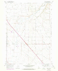
1968 Map of Malta NE
USGS Topo · Published 1978About this map
The Raft River Valley in southern Idaho defines this landscape, where the Raft River meanders north through a vast expanse of agricultural and industrial infrastructure. Photogrammetric surveys from the late 1960s reveal a network of utility and transport, including a prominent Pipeline and the Idahome Road cutting across the valley floor. The map highlights the intensive resource management of the era, documented by numerous irrigation wells and several extraction sites such as a Sandpit and various Borrow Pits. Water management is further evidenced by a Substation and the confluence of seasonal flows from Warm Creek and Shirley Creek. These features illustrate the mid-century development of Cassia County, balancing livestock fencing with the growing needs of regional power and water distribution.
Find a feature on this map
13 named features on this map. Tap any name to fly to it.
Don’t see what you’re looking for? This feature index may not catch every label — zoom into the map to look around manually.
Map Details
Editions of this 1968 Malta NE Map
2 editions found
Other maps of this area

1954 · Pocatello
USGS Topo · 1:250,000

1958 · Pocatello
USGS Topo · 1:250,000

1958 · Sublett
USGS Topo · 1:62,500

1959 · Lake Walcott
USGS Topo · 1:62,500

1959 · Yale
USGS Topo · 1:62,500

1968 · Malta NE
USGS Topo · 1:24,000

1968 · Malta
USGS Topo · 1:24,000

1968 · Idahome
USGS Topo · 1:24,000

1968 · Nibbs Creek
USGS Topo · 1:24,000

1984 · North Chapin Mountain
USGS Topo · 1:24,000