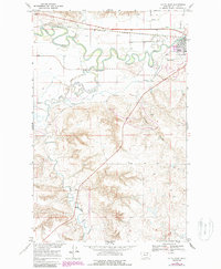
1968 Map of Malta West
USGS Topo · Published 1987About this map
The city of Malta, the county seat of Phillips County, sits at a bend of the Milk River where the High Plains meet the river valley. In the late 1960s, this area was a hub of transport and irrigation, defined by the winding course of the river and the parallel routes of the Burlington Northern railroad and the Dodson Clark Trail. The map reveals the intricate water management system of the era, including the North Canal and South Canal, which diverted water to support agriculture in this arid landscape. South of the river valley, the terrain rises toward Taylor Hill, dissected by natural drainages like Alkali Creek and Taylor Coulee. Revisions from 1987 illustrate the expansion of the Malta Airport and the evolving footprint of the town, documenting the transition of this prairie community through the mid-20th century.
Find a feature on this map
15 named features on this map. Tap any name to fly to it.
Don’t see what you’re looking for? This feature index may not catch every label — zoom into the map to look around manually.
Map Details
Editions of this 1968 Malta West Map
2 editions found
Other maps of this area

1953 · Havre
USGS Topo · 1:250,000

1954 · Glasgow
USGS Topo · 1:250,000

1957 · Glasgow
USGS Topo · 1:250,000

1957 · Havre
USGS Topo · 1:250,000

1958 · Glasgow
USGS Topo · 1:250,000

1958 · Havre
USGS Topo · 1:250,000

1964 · Dodson NE
USGS Topo · 1:24,000

1965 · Wagner
USGS Topo · 1:24,000

1965 · West Alkali Reservoir
USGS Topo · 1:24,000

1968 · Malta West
USGS Topo · 1:24,000