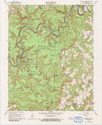
1965 Map of Mammoth Cave
USGS Topo · Published 1988About this map
The Green River carves a deep, winding path through this portion of Kentucky, anchoring the complex topography above Mammoth Cave National Park. The map reveals a landscape defined by its subterranean world, marking numerous access points including the Mammoth Cave (Historic Entrance), the Violet City Entrance, and the Frozen Niagara Entrance. Beyond the famous caverns, the sheet documents the rural community infrastructure that existed within and around the park boundaries during the mid-1950s. Family and community history is preserved through labels for the Old Guides Cemetery, Mammoth Cave Ch, and several isolated burial grounds like Little Jordan Cem and Wilkins Cem. The rugged surface is a maze of named sinks and hollows, such as Sugar Sink and Holton Hollow, while the river still shows the location of the Dennison Ferry, illustrating the historic transit patterns of Edmonson and Hart counties before modern bridges dominated the region.
Find a feature on this map
103 named features on this map. Tap any name to fly to it.
Don’t see what you’re looking for? This feature index may not catch every label — zoom into the map to look around manually.
Map Details
Editions of this 1965 Mammoth Cave Map
2 editions found
Other maps of this area

1922 · Mammoth Cave
USGS Topo · 1:62,500

1923 · Mammoth Cave
USGS Topo · 1:62,500

1925 · Cub Run
USGS Topo · 1:62,500

1934 · Munfordville
USGS Topo · 1:48,000

1935 · Horse Cave
USGS Topo · 1:48,000

1937 · Munfordville
USGS Topo · 1:62,500

1938 · Horse Cave
USGS Topo · 1:62,500

1953 · Munfordville
USGS Topo · 1:24,000

1954 · Evansville
USGS Topo · 1:250,000

1954 · Horse Cave
USGS Topo · 1:24,000