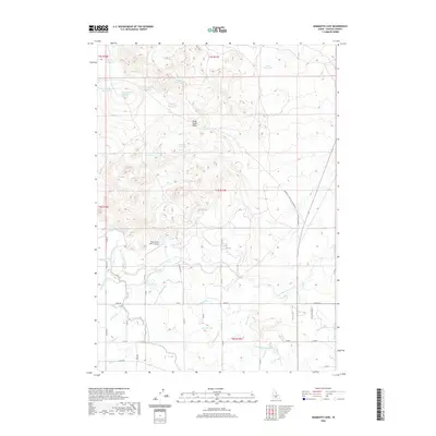
2020 Map of Mammoth Cave
USGS Topo · Published 2020About this map
Black Butte Hills dominate the topography of this high desert landscape, which is defined by an extensive network of water management infrastructure. The region's reliance on irrigation is evident in the complex system of canals and laterals, most notably the Milner-Gooding Canal and the North Shoshone Canal. These waterways snake through the arid terrain to support local ranching operations like those served by the Black Butte Ranch Airport. A series of small-scale impoundments, including Green Spring Reservoir, Big Draw Reservoir, and Tom Gooding Lake, are scattered across the northern sections, illustrating the critical nature of water storage in Lincoln County. The map also traces the path of Mammoth Cave Rd, which leads toward the geological features that give this quadrangle its name, alongside local thoroughfares such as Parker Gulch Rd and Upper Rd.
Find a feature on this map
49 named features on this map. Tap any name to fly to it.
Don’t see what you’re looking for? This feature index may not catch every label — zoom into the map to look around manually.
Map Details
Editions of this 2020 Mammoth Cave Map
This is the sole edition of this map. No revisions or reprints were ever made.
Other maps of this area

1955 · Twin Falls
USGS Topo · 1:250,000

1955 · Hailey
USGS Topo · 1:250,000

1957 · Thorn Creek SE
USGS Topo · 1:24,000

1957 · Thorn Creek
USGS Topo · 1:62,500

1958 · Twin Falls
USGS Topo · 1:250,000

1959 · Hailey
USGS Topo · 1:250,000

1962 · Hailey
USGS Topo · 1:250,000

1971 · Dietrich
USGS Topo · 1:24,000

1971 · Tunupa
USGS Topo · 1:24,000
1971 · Shoshone
USGS Topo · 1:24,000