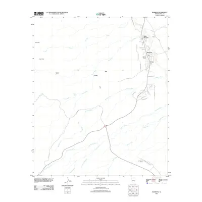
2011 Map of Mammoth
USGS Topo · Published 2011About this map
Mammoth and North Mammoth anchor this landscape along the banks of the San Pedro River, where the town layout reflects its relationship with the river corridor and regional transportation. To the west, the arid terrain rises into the Black Hills and Signal Peak, cut by a complex drainage system including Tucson Wash, Tar Wash, and Mammoth Wash. This 2011 survey documents a transition from the structured residential blocks of the river settlements to the more dispersed legacy of mining and ranching areas like Tiger and Fordville. For genealogists and local historians, the sheet preserves the location of the Mammoth Valley View Cemetery and the McKinney Cemetery, providing vital links to family histories in Pinal County. Notable infrastructure such as the San Manuel Airport and Mammoth Swimming Pool further illustrate the community's modern footprint within this desert environment.
Find a feature on this map
37 named features on this map. Tap any name to fly to it.
Don’t see what you’re looking for? This feature index may not catch every label — zoom into the map to look around manually.
Map Details
Editions of this 2011 Mammoth Map
This is the sole edition of this map. No revisions or reprints were ever made.
Other maps of this area

1911 · Winkelman
USGS Topo · 1:125,000

1913 · Winkelman
USGS Topo · 1:125,000

1948 · Clark Ranch
USGS Topo · 1:24,000

1948 · Mammoth
USGS Topo · 1:62,500

1948 · Mammoth
USGS Topo · 1:24,000

1948 · Campo Bonito
USGS Topo · 1:24,000

1948 · Peppersauce Wash
USGS Topo · 1:24,000

1949 · Clark Ranch
USGS Topo · 1:24,000

1949 · Mammoth
USGS Topo · 1:24,000

1949 · Campo Bonito
USGS Topo · 1:24,000