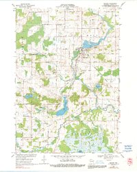
1969 Map of Manawa
USGS Topo · Published 1991About this map
Manawa serves as the primary hub of this landscape, situated along a sharp bend of the Little Wolf River. Based on a 1969 field check, this survey captures the town's spatial arrangement including the central business district, industrial areas, and residential growth typical of mid-century Wisconsin river towns. The Little Wolf River dominates the geography, winding through the terrain and influencing the placement of local infrastructure and development. While feature-sparse compared to more densely populated areas, this map provides a clear look at the relationship between the settlement of Manawa and its surrounding water resources during the late 1960s.
Find a feature on this map
2 named features on this map. Tap any name to fly to it.
Don’t see what you’re looking for? This feature index may not catch every label — zoom into the map to look around manually.
Map Details
Editions of this 1969 Manawa Map
2 editions found
Other maps of this area

1955 · Clintonville
USGS Topo · 1:48,000

1955 · Tigerton
USGS Topo · 1:48,000

1955 · Green Bay
USGS Topo · 1:250,000

1956 · Weyauwega
USGS Topo · 1:48,000

1957 · Waupaca
USGS Topo · 1:48,000

1969 · Readfield
USGS Topo · 1:24,000

1969 · Northport
USGS Topo · 1:24,000
1969 · Manawa
USGS Topo · 1:24,000
1969 · Weyauwega
USGS Topo · 1:24,000
1969 · Waupaca
USGS Topo · 1:24,000