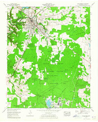
1963 Map of Manchester
USGS Topo · Published 1965About this map
The confluence of the Duck River and Little Duck River anchors this 1960s study of central Tennessee, where the ancient Old Stone Fort and Indian mound sit just west of the growing seat of Manchester. The landscape is a study in technological transition, dominated to the south by the sprawling Arnold Engineering Development Center (U S Air Force) and its associated Wildlife Management Area. This military installation, surrounded by a distinct Reservation Boundary, significantly altered the local geography of The Barrens, creating large water features like Sinking Pond and Goose Pond.
Find a feature on this map
70 named features on this map. Tap any name to fly to it.
Don’t see what you’re looking for? This feature index may not catch every label — zoom into the map to look around manually.
Map Details
Editions of this 1963 Manchester Map
This is the sole edition of this map. No revisions or reprints were ever made.
Other maps of this area

1893 · Mc Minnville
USGS Topo · 1:125,000

1895 · Mc Minnville
USGS Topo · 1:125,000

1895 · Sewanee
USGS Topo · 1:125,000

1913 · Hollow Springs
USGS Topo · 1:62,500

1936 · Ovoca
USGS Topo · 1:24,000

1936 · Alto
USGS Topo · 1:24,000

1936 · Fredonia
USGS Topo · 1:24,000
1936 · Manchester
USGS Topo · 1:24,000

1936 · Noah
USGS Topo · 1:24,000
1936 · Morrison
USGS Topo · 1:24,000