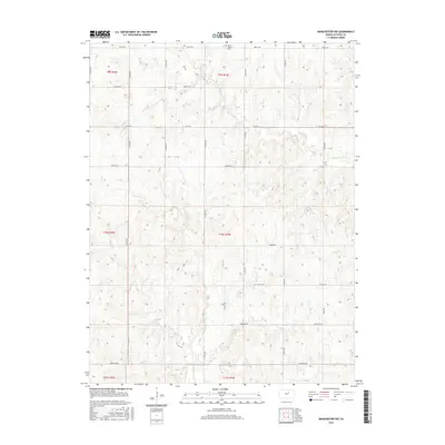
2015 Map of Manchester NW
USGS Topo · Published 2015About this map
Mount Liberty Cem sits along the northern edge of this section of Ottawa County, a quiet landmark in a landscape defined by its rural grid and winding prairie streams. This 2015 survey reveals the hydrological network of north-central Kansas, where the headwaters of W Chapman Cr, Badger Cr, Coal Cr, and Vine Cr carve subtle drainages through the agricultural uplands. The terrain is organized by a strict network of section-line roads, including Treaty Rd and Limestone Rd, which facilitate movement across the township boundaries. These roads and waterways illustrate the enduring spatial logic of the Great Plains, where the Public Land Survey System persists as the primary framework for both transportation and land management in the 21st century.
Find a feature on this map
19 named features on this map. Tap any name to fly to it.
Don’t see what you’re looking for? This feature index may not catch every label — zoom into the map to look around manually.
Map Details
Editions of this 2015 Manchester NW Map
This is the sole edition of this map. No revisions or reprints were ever made.
Other maps of this area

1891 · Clay Center
USGS Topo · 1:125,000

1892 · Minneapolis
USGS Topo · 1:125,000

1955 · Manhattan
USGS Topo · 1:250,000

1956 · Manhattan
USGS Topo · 1:250,000

1957 · Manhattan
USGS Topo · 1:250,000

1964 · Lamar
USGS Topo · 1:24,000

1964 · Idana
USGS Topo · 1:24,000

1964 · Miltonvale
USGS Topo · 1:24,000
1965 · Manchester NW
USGS Topo · 1:24,000
1965 · Vine Creek
USGS Topo · 1:24,000