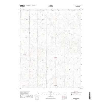
2018 Map of Manchester NW
USGS Topo · Published 2018About this map
Mount Liberty Cem sits along the northern edge of this landscape in Ottawa County, marking a quiet point in a region defined by its undulating drainage patterns. The land is intricately carved by several waterways, including W Chapman Cr, Coal Cr, Badger Cr, and Vine Cr, which dictate the topography of this rural section of Kansas. The road network follows a strict sectional grid, yet many routes carry evocative names that hint at the local geology and history, such as Limestone Rd, Quartz Rd, and Nugget Rd. To the north, Treaty Rd runs along the township line, while Mulberry Rd and Oxbow Rd cut through the central reaches. This survey provides a clear view of the rural homestead distribution and land management divisions within townships like t10s r1w and t9s r1w during the early 21st century.
Find a feature on this map
25 named features on this map. Tap any name to fly to it.
Don’t see what you’re looking for? This feature index may not catch every label — zoom into the map to look around manually.
Map Details
Editions of this 2018 Manchester NW Map
This is the sole edition of this map. No revisions or reprints were ever made.
Other maps of this area

1891 · Clay Center
USGS Topo · 1:125,000

1892 · Minneapolis
USGS Topo · 1:125,000

1955 · Manhattan
USGS Topo · 1:250,000

1956 · Manhattan
USGS Topo · 1:250,000

1957 · Manhattan
USGS Topo · 1:250,000

1964 · Lamar
USGS Topo · 1:24,000

1964 · Idana
USGS Topo · 1:24,000

1964 · Miltonvale
USGS Topo · 1:24,000
1965 · Manchester NW
USGS Topo · 1:24,000
1965 · Vine Creek
USGS Topo · 1:24,000