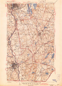
1941 Map of Manchester
USGS Topo · Published 1944About this map
The industrial and transportation hubs of Manchester and Nashua anchor this mid-century survey of the Merrimack River valley. The landscape is defined by its deep connections to the B and M R R, with the Concord Division tracing the river and the Manchester and Lawrence Division cutting through the interior towns of Londonderry and Windham Depot. Local landmarks like Pine Grove Cemetery and St Marie Convent offer specific points of interest for genealogists, while the presence of the Pennichuck Waterworks and U S Fish Hatchery reflects the region's managed water resources.
Find a feature on this map
96 named features on this map. Tap any name to fly to it.
Don’t see what you’re looking for? This feature index may not catch every label — zoom into the map to look around manually.
Map Details
Editions of this 1941 Manchester Map
3 editions found

Other maps of this area

1886 · Lawrence
USGS Topo · 1:62,500

1886 · Lowell
USGS Topo · 1:62,500

1888 · Haverhill
USGS Topo · 1:62,500

1888 · Lawrence
USGS Topo · 1:62,500

1890 · Haverhill
USGS Topo · 1:62,500

1893 · Lowell
USGS Topo · 1:62,500

1893 · Lawrence
USGS Topo · 1:62,500

1893 · Haverhill
USGS Topo · 1:62,500

1893 · Groton
USGS Topo · 1:62,500

1905 · Manchester
USGS Topo · 1:62,500