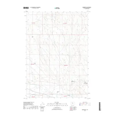
2017 Map of Manderson SE
USGS Topo · Published 2017About this map
The Nowood River cuts through the southern portion of this landscape in Big Horn County, serving as a primary water source for local agricultural efforts. Traces of human engineering are evident in the Avent Ditch and Shafer Ditch, which redirect water across the arid terrain. The map reveals a transition from the broad Basin Flats in the west to more complex drainage systems in the east, characterized by McDermotts Gulch and the East Fork McDermotts Gulch. This area is defined by its deep arroyos and intermittent watercourses like Alkali Cr, while prominent landforms such as Blue Ridge provide navigational landmarks. The layout of Co LN 50 and Ainsworth Unit Rd indicates the sparse but vital transport network supporting local ranching operations in this part of Wyoming.
Find a feature on this map
18 named features on this map. Tap any name to fly to it.
Don’t see what you’re looking for? This feature index may not catch every label — zoom into the map to look around manually.
Map Details
Editions of this 2017 Manderson SE Map
This is the sole edition of this map. No revisions or reprints were ever made.
Other maps of this area

1955 · Sheridan
USGS Topo · 1:250,000

1958 · Sheridan
USGS Topo · 1:250,000

1960 · White Sulphur Spring
USGS Topo · 1:24,000

1960 · Manderson
USGS Topo · 1:24,000

1960 · Flitner Reservoir
USGS Topo · 1:24,000

1960 · Manderson NE
USGS Topo · 1:24,000

1960 · Manderson SE
USGS Topo · 1:24,000

1960 · Wild Horse Flats
USGS Topo · 1:24,000

1962 · Sheridan
USGS Topo · 1:250,000
1967 · Weintz Draw
USGS Topo · 1:24,000