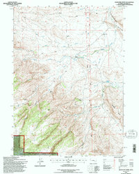
1992 Map of Maneater Creek
USGS Topo · Published 1996About this map
The Medicine Bow National Forest occupies the southern reaches of this landscape, where the foothills of the Laramie Mountains begin their ascent from the high plains. In the early 1990s, this area of Converse County remained characterized by isolated homesteads and ranching infrastructure, such as Raeber Ranch and Middleton Ranch, connected by the Upper Wagon Hound Road. The intricate drainage network of Wagon Hound Creek and La Bonte Creek defines the terrain, supported by early water management features like the George Nagle Ditch and Wagon Hound Ditch No 3. These irrigation systems speak to the long-standing efforts to sustain livestock in the arid Wyoming basin. Local history is anchored by the Wagon Hound Sch, a solitary educational landmark serving the dispersed population near Kenny and the Rogers Place.
Find a feature on this map
25 named features on this map. Tap any name to fly to it.
Don’t see what you’re looking for? This feature index may not catch every label — zoom into the map to look around manually.
Map Details
Editions of this 1992 Maneater Creek Map
This is the sole edition of this map. No revisions or reprints were ever made.
Other maps of this area

1943 · Esterbrook
USGS Topo · 1:62,500

1945 · Esterbrook
USGS Topo · 1:62,500

1949 · Poison Lake
USGS Topo · 1:24,000

1949 · Chalk Buttes
USGS Topo · 1:24,000

1950 · Poison Lake
USGS Topo · 1:24,000
1950 · Chalk Buttes
USGS Topo · 1:24,000

1954 · Torrington
USGS Topo · 1:250,000

1958 · Torrington
USGS Topo · 1:250,000

1964 · School Section Mountain
USGS Topo · 1:24,000
1964 · Hermit Rock
USGS Topo · 1:24,000