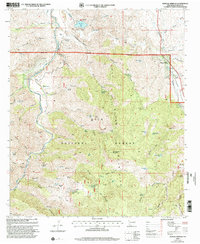
1999 Map of Mangas Springs
USGS Topo · Published 2002About this map
Mangas Springs serves as a focal point in this high-desert landscape within the Gila National Forest, where water sources dictate the patterns of human activity. The map reveals a complex system of livestock and water management, featuring numerous named tanks like Blue Stone Tank and Fence Line Tank, alongside an Aqueduct and Pumping Station near Bill Evans Lake. Mining history is evident at the Telegraph Mine and Cora Miller Mine, while the winding Gila River provides a riparian corridor marked by the Gila River Bird Area Vista. The transition from the alluvial Mangas Valley to the uplifted terrain of Schoolhouse Mountain and Wild Horse Mesa illustrates the area's geological diversity. Local ranching legacies are anchored by sites such as the Hap McCauley Ranch, while the small settlement of Cliff and a lone Cemetery record the footprint of earlier 20th-century residents in this corner of Grant County.
Find a feature on this map
77 named features on this map. Tap any name to fly to it.
Don’t see what you’re looking for? This feature index may not catch every label — zoom into the map to look around manually.
Map Details
Editions of this 1999 Mangas Springs Map
This is the sole edition of this map. No revisions or reprints were ever made.
Other maps of this area

1909 · Silver City
USGS Topo · 1:125,000

1949 · Circle Mesa
USGS Topo · 1:24,000

1950 · Dorsey Ranch
USGS Topo · 1:24,000

1950 · Wind Mountain
USGS Topo · 1:24,000

1951 · Circle Mesa
USGS Topo · 1:24,000

1951 · Dorsey Ranch
USGS Topo · 1:24,000

1951 · Wind Mountain
USGS Topo · 1:24,000

1954 · Silver City
USGS Topo · 1:250,000

1958 · Silver City
USGS Topo · 1:250,000

1959 · Redrock
USGS Topo · 1:62,500