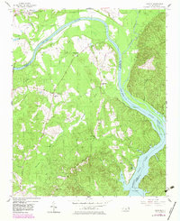
1956 Map of Mangum
USGS Topo · Published 1983About this map
The Pee Dee River defines the border between Anson and Richmond counties, winding through a landscape of creek-fed bottomlands and ridges. This mid-century survey, updated with late 20th-century details, documents the rural infrastructure of the North Carolina interior. Along the river, the presence of Old Stanback Ferry and Old Smith Ferry highlights former crossing points that once connected these riverine communities before the dominance of modern bridges.
Find a feature on this map
37 named features on this map. Tap any name to fly to it.
Don’t see what you’re looking for? This feature index may not catch every label — zoom into the map to look around manually.
Map Details
Editions of this 1956 Mangum Map

Other maps of this area

1941 · Spartanburg
USGS Topo · 1:250,000

1942 · Troy
USGS Topo · 1:125,000

1942 · Rockingham
USGS Topo · 1:125,000

1953 · Florence
USGS Topo · 1:250,000

1953 · Raleigh
USGS Topo · 1:250,000

1953 · Spartanburg
USGS Topo · 1:250,000

1953 · Charlotte
USGS Topo · 1:250,000

1954 · Charlotte
USGS Topo · 1:250,000

1954 · Florence
USGS Topo · 1:250,000

1954 · Raleigh
USGS Topo · 1:250,000