1947 Map of Manhattan
USGS Topo · Published 1954About this map
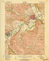
Manhattan sits at the confluence of the Kansas River and Big Blue River, serving as a hub for both higher education and military operations in the post-war era. The extensive campus of Kansas State College dominates the northern end of town, while to the southwest, the Fort Riley Military Reservation and Camp Funston occupy a massive stretch of the river valley. The landscape is carved by numerous family-named landmarks and rural institutions, including St Marys Cem and the McDowell Creek Sch, reflecting a deeply settled agricultural hinterland. Transport networks are well-established by 1947, with both the Union Pacific and Chicago Rock Island and Pacific railroads following the river corridors. Smaller airfields like Pottawatomie Airport and Manhattan Airport signify the early growth of regional aviation alongside traditional settlements like Ogden and Keats.
Find a feature on this map
67 named features on this map. Tap any name to fly to it.
Don’t see what you’re looking for? This feature index may not catch every label — zoom into the map to look around manually.
Map Details
Editions of this 1947 Manhattan Map
2 editions found

Other maps of this area

1885 · Eskridge
USGS Topo · 1:125,000

1886 · Junction City
USGS Topo · 1:125,000

1889 · Wamego
USGS Topo · 1:125,000

1889 · Junction City
USGS Topo · 1:125,000

1889 · Parkerville
USGS Topo · 1:125,000

1889 · Eskridge
USGS Topo · 1:125,000

1894 · Eskridge
USGS Topo · 1:125,000

1894 · Junction City
USGS Topo · 1:125,000

1894 · Parkerville
USGS Topo · 1:125,000

1894 · Wamego
USGS Topo · 1:125,000