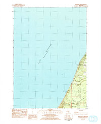
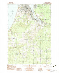
1982 Map of Manistee NW
USGS Topo · Published 1984About this map
Lake Michigan dominates the western shoreline along this stretch of the Michigan coast, where the waters meet the wooded expanse of the Manistee National Forest. The map documents a sparsely settled landscape defined by the boundary between Manistee and Mason counties. A network of rural corridors including Sass Road, Jepson Road, and Freesoil Road grid the interior, providing access to the coastal bluffs and forested tracts. Along the southern edge of the sheet, Cooper Creek winds toward the lake, crossed by Cooper Road. The presence of the Indian Trail suggests older transit patterns integrated into the modern road system. This survey represents the topography and land use of the early 1980s, highlighting the intersection of managed federal forest lands and private rural holdings just north of the more developed coastal centers.
Find a feature on this map
11 named features on this map. Tap any name to fly to it.
Don’t see what you’re looking for? This feature index may not catch every label — zoom into the map to look around manually.
Map Details
Editions of this 1982 Manistee NW Map
This is the sole edition of this map. No revisions or reprints were ever made.
Other maps of this area

1931 · Manistee SE
USGS Topo · 1:31,680

1931 · Manistee SW
USGS Topo · 1:31,680

1954 · Manitowoc
USGS Topo · 1:250,000

1956 · Bar Lake
USGS Topo · 1:62,500

1958 · Manitowoc
USGS Topo · 1:250,000

1958 · Manistee
USGS Topo · 1:62,500
1976 · Bar Lake SE
USGS Topo · 1:24,000
1982 · Hamlin Lake
USGS Topo · 1:25,000
1982 · Kings Corners
USGS Topo · 1:25,000
1982 · Manistee
USGS Topo · 1:25,000