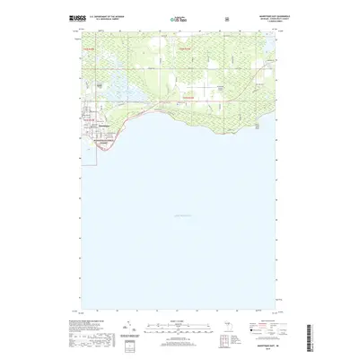
2019 Map of Manistique East
USGS Topo · Published 2019About this map
Manistique sits at the convergence of the Manistique River and Lake Michigan, serving as a coastal hub where the industrial and natural landscapes of the Upper Peninsula meet. The town grid is clearly defined, housing civic landmarks like the Schoolcraft County Courthouse and the unique engineering of the Siphon Bridge. North and east of the town center, the landscape transitions into the wooded expanses of the Hiawatha National Forest, interspersed with low-lying wetlands such as Jamestown Slough and Island Slough.
Find a feature on this map
46 named features on this map. Tap any name to fly to it.
Don’t see what you’re looking for? This feature index may not catch every label — zoom into the map to look around manually.
Map Details
Editions of this 2019 Manistique East Map
This is the sole edition of this map. No revisions or reprints were ever made.
Other maps of this area

1931 · Cooks NE
USGS Topo · 1:31,680

1931 · Steuben SE
USGS Topo · 1:31,680

1931 · Manistique River SE
USGS Topo · 1:31,680

1931 · Manistique River SW
USGS Topo · 1:31,680

1954 · Escanaba
USGS Topo · 1:250,000

1957 · Escanaba
USGS Topo · 1:250,000

1958 · Escanaba
USGS Topo · 1:250,000

1958 · Cooks
USGS Topo · 1:62,500
1958 · Steuben
USGS Topo · 1:62,500

1958 · Marquette
USGS Topo · 1:250,000