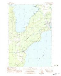
1983 Map of Manistique West
USGS Topo · Published 1984About this map
The western edges of Manistique and the neighboring settlement of Thompson anchor this coastal survey along the northern shores of Lake Michigan. The landscape is defined by the transition from the Hiawatha National Forest and Lake Superior State Forest to the sandy reaches of Indian Lake. This era shows a community balanced between its industrial roots and its emerging role in Great Lakes recreation, evidenced by the Southtown Railroad Grade and Old Railroad Grade running near modern facilities like the Fish Hatchery Thompson. Local history is preserved at the Ossawinamakee Beach Historic Site and the Thompson Cem, while small residential pockets like Hiawatha Shores and Evergreen Shores line the waterfront. Numerous small tributaries, including Dufour Creek, Thompson Creek, and Williams Creek, drain the forested interior toward the big lake, passing by Indian Lake State Park and the distinct breakwater protecting the harbor approach.
Find a feature on this map
45 named features on this map. Tap any name to fly to it.
Don’t see what you’re looking for? This feature index may not catch every label — zoom into the map to look around manually.
Map Details
Editions of this 1983 Manistique West Map
This is the sole edition of this map. No revisions or reprints were ever made.
Other maps of this area

1931 · Cooks NE
USGS Topo · 1:31,680

1931 · Steuben SE
USGS Topo · 1:31,680

1931 · Steuben SW
USGS Topo · 1:31,680

1931 · Cooks NW
USGS Topo · 1:31,680

1931 · Manistique River SW
USGS Topo · 1:31,680

1954 · Escanaba
USGS Topo · 1:250,000

1957 · Escanaba
USGS Topo · 1:250,000

1958 · Escanaba
USGS Topo · 1:250,000

1958 · Cooks
USGS Topo · 1:62,500
1958 · Steuben
USGS Topo · 1:62,500