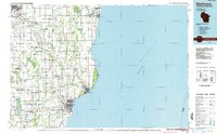
1984 Map of Manitowoc
USGS Topo · Published 1985About this map
Lake Michigan dominates the eastern half of this mid-1980s landscape, shaping the industrial and recreational character of the coastline from the U S Coast Guard Station at Two Rivers down to the Manitowoc Harbor. The map captures a transitional era for the region's infrastructure, showing the Chicago and North Western railroad lines serving the port cities while a ferry route extends across the open water toward Michigan. Inland, the terrain is defined by the winding paths of the Neshota River and West Twin River, punctuated by established rural communities like Stangelville, Tisch Mills, and Francis Creek. Significant conservation areas, including the Point Beach State Forest and Collins Marsh State Wildlife Management Area, provide a clear view of the protected wetlands and forests that break up the agricultural grid of eastern Wisconsin.
Find a feature on this map
99 named features on this map. Tap any name to fly to it.
Don’t see what you’re looking for? This feature index may not catch every label — zoom into the map to look around manually.
Map Details
Editions of this 1984 Manitowoc Map
2 editions found
Other maps of this area

1952 · Casco
USGS Topo · 1:62,500

1954 · De Pere
USGS Topo · 1:62,500

1954 · Kewaunee
USGS Topo · 1:62,500

1954 · School Hill
USGS Topo · 1:24,000

1954 · Manitowoc
USGS Topo · 1:62,500

1954 · Cleveland
USGS Topo · 1:24,000

1954 · Green Bay West
USGS Topo · 1:24,000

1954 · St. Wendel
USGS Topo · 1:24,000

1954 · Sheboygan North
USGS Topo · 1:62,500

1954 · Denmark
USGS Topo · 1:62,500