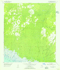
1955 Map of Manlin Hammock
USGS Topo · Published 1956About this map
Manlin Hammock and the surrounding coastal marshlands of Taylor County define this mid-1950s survey, where the Gulf of Mexico meets a complex network of tidal creeks and dense hammocks. The landscape is marked by a legacy of industrial activity, most notably the winding paths of an Old Railroad Grade that once serviced the local timber or turpentine industries. This infrastructure cuts through the wetlands near Camp Misery, a named settlement reflecting the challenging environment of the Florida Big Bend.
Find a feature on this map
12 named features on this map. Tap any name to fly to it.
Don’t see what you’re looking for? This feature index may not catch every label — zoom into the map to look around manually.
Map Details
Editions of this 1955 Manlin Hammock Map
3 editions found

Other maps of this area

1952 · Secotan
USGS Topo · 1:24,000

1954 · Johnson Hammock
USGS Topo · 1:24,000

1954 · Hampton Springs
USGS Topo · 1:24,000

1954 · Secotan
USGS Topo · 1:24,000

1954 · Okefenokee Slough
USGS Topo · 1:24,000

1954 · Gainesville
USGS Topo · 1:250,000

1954 · Valdosta
USGS Topo · 1:250,000

1955 · Snipe Island
USGS Topo · 1:24,000

1955 · Nutall Rise
USGS Topo · 1:24,000

1955 · Rock Islands
USGS Topo · 1:24,000