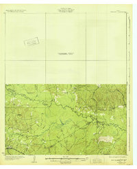
1932 Map of Manning
USGS Topo · Published 1932About this map
The Neches River winds through this 1932 preliminary survey of East Texas, marking a rugged boundary between Angelina, Polk, and Tyler Counties. The landscape is defined by the heavy presence of logging infrastructure, notably the Timber RR and the Lufkin Waco Beaumont Trinity and Sabine RR which cuts across the southern portion of the sheet. At the time of this survey, much of the northern half of the quadrangle remained an unsurveyed area, leaving the dense creek systems of the south to represent the primary documented terrain. Small rural outposts like Pluck PO and Harris Spring serve as the principal centers of local life, alongside a network of country schools including Seaman Ridge Sch and Crane Sch. For genealogists and local historians, the map provides precise locations for Paige Cem and Hanard Cem, as well as the Lambert Chapel, grounding early 20th-century family history in the specific creek-bottom geography of the Piney Woods.
Find a feature on this map
47 named features on this map. Tap any name to fly to it.
Don’t see what you’re looking for? This feature index may not catch every label — zoom into the map to look around manually.
Map Details
Editions of this 1932 Manning Map
Other maps of this area

1927 · Lufkin 4-c
USGS Topo · 1:24,000

1928 · Zavalla 3-c
USGS Topo · 1:24,000

1928 · Lufkin 4-d
USGS Topo · 1:24,000

1931 · Zavalla
USGS Topo · 1:62,500

1932 · Manning
USGS Topo · 1:62,500

1949 · Lufkin
USGS Topo · 1:62,500

1949 · Lufkin
USGS Topo · 1:24,000

1949 · Huntington
USGS Topo · 1:24,000

1949 · Keltys
USGS Topo · 1:24,000

1950 · Keltys
USGS Topo · 1:24,000