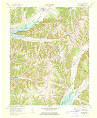
1970 Map of Mannsville
USGS Topo · Published 1972About this map
Green River Lake dominates the drainage of this central Kentucky landscape, where the waters of Robinson Creek and Stoner Creek meet the reservoir. The topography is defined by a dense network of ridges, including Long Ridge and Speck Ridge, which dictated the early settlement patterns of communities like Mannsville and Feathersburg. This 1970 revision reveals a rural economy transitioning around the newly formed lake, with multiple pipelines traversing the hills.
Find a feature on this map
52 named features on this map. Tap any name to fly to it.
Don’t see what you’re looking for? This feature index may not catch every label — zoom into the map to look around manually.
Map Details
Editions of this 1970 Mannsville Map
This is the sole edition of this map. No revisions or reprints were ever made.
Other maps of this area

1952 · Clementsville
USGS Topo · 1:24,000

1952 · Mannsville
USGS Topo · 1:24,000

1952 · Bradfordsville
USGS Topo · 1:24,000

1953 · Campbellsville
USGS Topo · 1:24,000

1953 · Bradfordsville NE
USGS Topo · 1:24,000

1953 · Spurlington
USGS Topo · 1:24,000

1953 · Dunnville
USGS Topo · 1:24,000

1953 · Cane Valley
USGS Topo · 1:24,000

1953 · Bradfordsville
USGS Topo · 1:24,000

1954 · Knifley
USGS Topo · 1:24,000