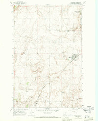
1968 Map of Mansfield
USGS Topo · Published 1971About this map
The town of Mansfield serves as the focal point of this high plateau landscape, captured during a period of transition for the region's agricultural infrastructure. The town is marked by its Grain Elevators, High Sch, and the Mansfield Airport, while the Burlington Northern railroad provides the primary industrial artery through the terrain. The presence of the Matthiesen School and the Buckingham Cem to the north suggests the historical distribution of rural families and early homesteads across the Douglas County hills. Geographic landmarks such as Lone Butte and Burke Hill rise above the surrounding flats, where water resources are defined by ephemeral features like Foster Draw, Buckingham Creek, and Alkali Wells. This survey detail illustrates the intersection of small-town development and dryland farming needs, shown through scattered Storage Bin locations and numerous borrow pits utilized for local road and rail maintenance.
Find a feature on this map
24 named features on this map. Tap any name to fly to it.
Don’t see what you’re looking for? This feature index may not catch every label — zoom into the map to look around manually.
Map Details
Editions of this 1968 Mansfield Map
2 editions found
Other maps of this area

1953 · Ritzville
USGS Topo · 1:250,000

1959 · Ritzville
USGS Topo · 1:250,000

1965 · Ritzville
USGS Topo · 1:250,000

1965 · Jameson Lake West
USGS Topo · 1:24,000

1965 · Jameson Lake East
USGS Topo · 1:24,000

1968 · Withrow
USGS Topo · 1:24,000

1968 · Chief Joseph Dam
USGS Topo · 1:24,000

1968 · Wells Dam
USGS Topo · 1:24,000

1968 · Coleman Hill
USGS Topo · 1:24,000
1968 · Mud Spring
USGS Topo · 1:24,000