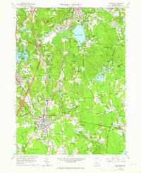
1964 Map of Mansfield
USGS Topo · Published 1966About this map
Massapoag Lake dominates the northern landscape of this 1964 revision, a period when the post-war expansion of the Boston-Providence corridor was beginning to reshape these industrial and residential communities. The New York New Haven and Hartford railroad cuts a definitive line through the terrain, connecting established centers like Sharon and Mansfield. Smaller, specialized enclaves such as Furnace Village and Whiteville suggest a history of localized industry often tied to the area's numerous water bodies, including Glue Factory Pond and Leach Pond. Significant institutional presence is visible at Sacred Heart College and the St Francis Retreat. Between the expanding residential footprints, the landscape retains complex natural features like Rattlesnake Hill and the Great Woods, which contrast with the developing infrastructure of the Boston-Providence Turnpike and the Municipal Airport.
Find a feature on this map
81 named features on this map. Tap any name to fly to it.
Don’t see what you’re looking for? This feature index may not catch every label — zoom into the map to look around manually.
Map Details
Editions of this 1964 Mansfield Map
Other maps of this area

1885 · Taunton
USGS Topo · 1:62,500

1886 · Dedham
USGS Topo · 1:62,500

1887 · Franklin
USGS Topo · 1:62,500

1887 · Providence
USGS Topo · 1:62,500

1888 · Taunton
USGS Topo · 1:62,500

1889 · Providence
USGS Topo · 1:62,500

1889 · Franklin
USGS Topo · 1:62,500

1893 · Taunton
USGS Topo · 1:62,500

1893 · Franklin
USGS Topo · 1:62,500

1894 · Dedham
USGS Topo · 1:62,500