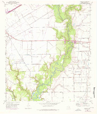
1952 Map of Manson
USGS Topo · Published 1976About this map
The Navidad River and Lavaca River converge in this mid-century portrait of Jackson County, carving a dense riparian landscape through the coastal plains. The local economy of the 1950s is clearly defined by the infrastructure of the Texana Oil Field and a network of pipelines and levees designed to manage the volatile river bottomlands. Industrial progress, represented by the Southern Pacific railroad and the Jackson County Airport, stands in contrast to the area's deeper history, visible in the presence of the Historical Monument and rural landmarks like Red Bluff Ch. This survey, updated with 1970s photorevisions, captures a period when the settlement at Manson was situated at the intersection of rail transport and emerging petroleum development. Genealogists can identify established community sites such as Brackenridge Cem and Red Bluff Cem, which provide specific points of reference for families settled along the river's winding course.
Find a feature on this map
23 named features on this map. Tap any name to fly to it.
Don’t see what you’re looking for? This feature index may not catch every label — zoom into the map to look around manually.
Map Details
Editions of this 1952 Manson Map
Other maps of this area

1952 · Francitas NW
USGS Topo · 1:24,000

1952 · Manson
USGS Topo · 1:24,000

1952 · Edna
USGS Topo · 1:24,000

1952 · La Salle
USGS Topo · 1:24,000

1952 · La Ward
USGS Topo · 1:24,000

1952 · Lolita
USGS Topo · 1:24,000

1953 · Beeville
USGS Topo · 1:250,000

1953 · Seguin
USGS Topo · 1:250,000

1956 · Beeville
USGS Topo · 1:250,000

1958 · Seguin
USGS Topo · 1:250,000