
1959 Map of Manvel
USGS Topo · Published 1977About this map
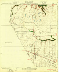
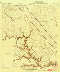
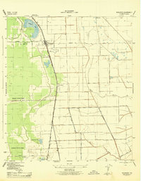
Manvel Oil Field and the nearby Hastings Oil Field dominate the northern landscape of this Brazoria County coastal plain, reflecting the region's mid-century petroleum development. The intersection of the Atchison Topeka and Santa Fe railroad with early thoroughfares like Old Manvel Road and Rifle Range Road anchors the small settlement of Manvel, which served as a rural center for surrounding ranches and oil workers. Further southeast, the town of Alvin shows significant expansion through the mid-1970s, with urban revisions highlighting its growth toward South Park and the Alvin Airpark.
Find a feature on this map
25 named features on this map. Tap any name to fly to it.
Don’t see what you’re looking for? This feature index may not catch every label — zoom into the map to look around manually.
Map Details
Editions of this 1959 Manvel Map
This is the sole edition of this map. No revisions or reprints were ever made.
Other maps of this area
1916 · Genoa
USGS Topo · 1:24,000

1920 · Genoa
USGS Topo · 1:31,680
1920 · Mykawa
USGS Topo · 1:31,680
1920 · Almeda
USGS Topo · 1:31,680

1929 · Algoa
USGS Topo · 1:24,000
1932 · Algoa
USGS Topo · 1:31,680
1932 · Genoa
USGS Topo · 1:31,680
1932 · Mustang Bayou
USGS Topo · 1:31,680
1943 · Rosharon
USGS Topo · 1:31,680
1943 · Mustang Bayou
USGS Topo · 1:31,680