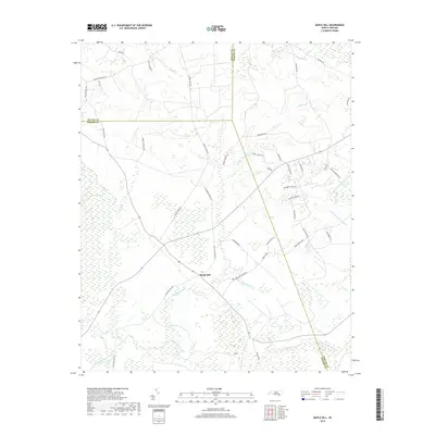
2019 Map of Maple Hill
USGS Topo · Published 2019About this map
Maple Hill serves as a central point in this part of southeastern North Carolina, situated near the meeting point of Duplin, Onslow, and Pender Counties. The landscape is defined by its extensive wetlands and water systems, notably the Angola Swamp to the west and the expansive Sandy Run Swamp and Little Sandy Run Swamp to the east. These low-lying areas dictate the settlement pattern, with roads like Old Maple Hill Rd N and Webbtown Rd following the higher ground between drainage basins. Local infrastructure and history are evident in names like Maple Hill School Rd and Sholar Mill Rd, suggesting the historical importance of local education and milling along the creeks. The area is heavily intersected by several watercourses including Cypress Creek, Holly Shelter Creek, and Tenmile Cr, which flow through the dense swamp forests that characterize this coastal plain environment.
Find a feature on this map
48 named features on this map. Tap any name to fly to it.
Don’t see what you’re looking for? This feature index may not catch every label — zoom into the map to look around manually.
Map Details
Editions of this 2019 Maple Hill Map
This is the sole edition of this map. No revisions or reprints were ever made.
Other maps of this area

1942 · Burgaw
USGS Topo · 1:62,500

1943 · Kenansville
USGS Topo · 1:62,500

1948 · Kenansville
USGS Topo · 1:62,500

1948 · Maple Hill
USGS Topo · 1:62,500

1948 · Richlands
USGS Topo · 1:62,500

1953 · Beaufort
USGS Topo · 1:250,000

1954 · Beaufort
USGS Topo · 1:250,000

1965 · Richlands
USGS Topo · 1:62,500

1972 · Beaufort
USGS Topo · 1:250,000
1980 · Richlands
USGS Topo · 1:62,500