
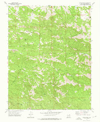
1972 Map of Maple Ridge
USGS Topo · Published 1992About this map
Dixie National Forest defines the rugged geography of this Washington County terrain, characterized by a complex network of high ridges and deep canyons. The central Bull Mountains dominate the landscape, flanked by named heights like Maple Ridge and Bull Mountain. These peaks are separated by a system of washes and canyons, including Racer Canyon and Moody Wash, which serve as natural corridors through the wilderness. Grounded details indicate human passage through this remote area, from the Veyo Shoal Creek Road to numerous pack trails that crisscross the flats and gulches.
Find a feature on this map
39 named features on this map. Tap any name to fly to it.
Don’t see what you’re looking for? This feature index may not catch every label — zoom into the map to look around manually.
Map Details
Editions of this 1972 Maple Ridge Map
2 editions found
Historical Maps of Washington County Through Time
103 maps found

1954 Beaver Dam Mts NE
Washington County, UT

1954 Beaver Dam Mts SE
Washington County, UT

1954 Gunlock
Washington County, UT

1954 La Verkin 1 SW
Washington County, UT

1954 La Verkin 2 SE
Washington County, UT

1954 La Verkin 3 NE
Washington County, UT

1954 La Verkin 3 NW
Washington County, UT

1954 La Verkin 3 SE
Washington County, UT

1954 La Verkin 3 SW
Washington County, UT

1954 La Verkin 4 NW
Washington County, UT

1954 La Verkin 4 SE
Washington County, UT

1954 La Verkin 4 SW
Washington County, UT

1954 Orderville Canyon NW
Washington County, UT

1956 Springdale SW
Washington County, UT

1956 St. George NE
Washington County, UT

1956 St. George NW
Washington County, UT

1956 St. George SE
Washington County, UT

1956 St. George SW
Washington County, UT

1972 Central East
Washington County, UT

1972 Central West
Washington County, UT

1972 Goldstrike
Washington County, UT

1972 Gunlock
Washington County, UT

1972 Hebron
Washington County, UT
1972 Maple Ridge
Washington County, UT

1972 Motoqua
Washington County, UT

1972 Pinto
Washington County, UT

1972 Saddle Mountain
Washington County, UT

1972 Water Canyon Peak
Washington County, UT

1973 Dodge Spring
Washington County, UT

1973 Scarecrow Peak
Washington County, UT

1980 Cogswell Point
Washington County, UT

1980 Kolob Arch
Washington County, UT

1980 Kolob Reservoir
Washington County, UT

1980 Little Creek Mountain
Washington County, UT

1980 Smith Mesa
Washington County, UT

1980 Smithsonian Butte
Washington County, UT

1980 Springdale East
Washington County, UT

1980 Springdale West
Washington County, UT

1980 Temple of Sinawava
Washington County, UT

1980 The Guardian Angels
Washington County, UT

1983 Castle Cliff
Washington County, UT

1983 Jarvis Peak
Washington County, UT

1983 Shivwits
Washington County, UT

1983 West Mountain Peak
Washington County, UT

1986 Grass Valley
Washington County, UT

1986 Harrisburg Junction
Washington County, UT

1986 Pintura
Washington County, UT

1986 Signal Peak
Washington County, UT

1986 The Divide
Washington County, UT

1986 Washington Dome
Washington County, UT

1986 White Hills
Washington County, UT

1996 The Guardian Angels
Washington County, UT

1997 Springdale East
Washington County, UT

1997 Temple of Sinawava
Washington County, UT

1999 Springdale West
Washington County, UT

2002 Central East
Washington County, UT

2002 Central West
Washington County, UT

2002 Goldstrike
Washington County, UT

2002 Grass Valley
Washington County, UT

2002 Gunlock
Washington County, UT

2002 Hebron
Washington County, UT

2002 Maple Ridge
Washington County, UT

2002 Pine Park
Washington County, UT

2002 Pinto
Washington County, UT

2002 Pintura
Washington County, UT

2002 Saddle Mountain
Washington County, UT

2002 Signal Peak
Washington County, UT

2002 Water Canyon
Washington County, UT

2023 Castle Cliff
Washington County, UT

2023 Central East
Washington County, UT

2023 Central West
Washington County, UT

2023 Cogswell Point
Washington County, UT

2023 Dodge Spring
Washington County, UT

2023 Goldstrike
Washington County, UT

2023 Grass Valley
Washington County, UT

2023 Gunlock
Washington County, UT

2023 Harrisburg Junction
Washington County, UT

2023 Hebron
Washington County, UT

2023 Jarvis Peak
Washington County, UT

2023 Kolob Arch
Washington County, UT

2023 Kolob Reservoir
Washington County, UT

2023 Little Creek Mountain
Washington County, UT

2023 Maple Ridge
Washington County, UT

2023 Motoqua
Washington County, UT

2023 Pine Park
Washington County, UT

2023 Pinto
Washington County, UT

2023 Pintura
Washington County, UT

2023 Saddle Mountain
Washington County, UT

2023 Saint George
Washington County, UT

2023 Scarecrow Peak
Washington County, UT

2023 Shivwits
Washington County, UT

2023 Signal Peak
Washington County, UT

2023 Smith Mesa
Washington County, UT

2023 Smithsonian Butte
Washington County, UT

2023 Springdale East
Washington County, UT

2023 Springdale West
Washington County, UT

2023 Temple of Sinawava
Washington County, UT

2023 The Divide
Washington County, UT

2023 The Guardian Angels
Washington County, UT

2023 Washington Dome
Washington County, UT

2023 Water Canyon Peak
Washington County, UT

2023 West Mountain Peak
Washington County, UT

2023 White Hills
Washington County, UT