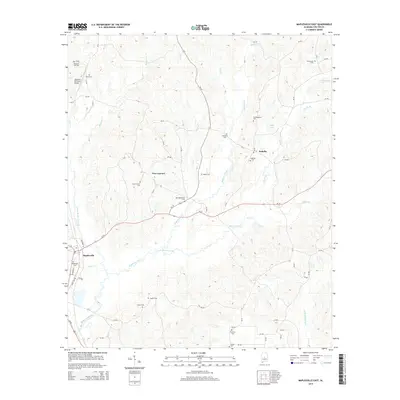
2014 Map of Maplesville East
USGS Topo · Published 2014About this map
Mulberry Creek and its many tributaries, including Byrd Creek, Benson Creek, and Bear Creek, define the topography of this central Alabama landscape. The settlement of Maplesville sits in the southwest corner, while the small community of Isabella and the area near New Convert anchor the central and northern sections of the map. This area is characterized by a high density of family and community burial grounds, which offer significant value for genealogical research. Notable sites include Old Maplesville Cemetery, Foshee Cemetery, and Old Raspberry Cemetery. The presence of the Mayfield (Private) Airport near the northern boundary and Calfee Lake to the east highlights the mixed-use nature of this rural terrain. Transportation is dominated by state routes Al-22 and Al-191, which connect these dispersed settlements across the creek valleys.
Find a feature on this map
69 named features on this map. Tap any name to fly to it.
Don’t see what you’re looking for? This feature index may not catch every label — zoom into the map to look around manually.
Map Details
Editions of this 2014 Maplesville East Map
This is the sole edition of this map. No revisions or reprints were ever made.
Other maps of this area

1891 · Clanton
USGS Topo · 1:125,000

1953 · Montgomery
USGS Topo · 1:250,000

1956 · Montgomery
USGS Topo · 1:250,000

1957 · Montgomery
USGS Topo · 1:250,000

1959 · Plantersville
USGS Topo · 1:62,500

1959 · Billingsley
USGS Topo · 1:62,500
1971 · Maplesville East
USGS Topo · 1:24,000
1971 · Jemison West
USGS Topo · 1:24,000

1971 · Maplesville West
USGS Topo · 1:24,000
1971 · Jemison East
USGS Topo · 1:24,000