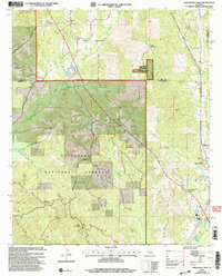
2002 Map of Maplesville West
USGS Topo · Published 2003About this map
Talladega National Forest encompasses much of this landscape along the border of Bibb and Chilton counties. In the early 2000s, the area remained defined by its rural character and the network of creeks that drain the forest, including Oakmulgee Creek and Honeysuckle Creek. Small settlements and family-named locales like Active, Lawley, and Maness dot the high ground between these drainages. Cultural landmarks are frequent in these upland pockets, such as Rehobeth Ch and Pleasant Grove Ch with its adjacent Pleasant Hill Cem. Near the eastern edge, the town of Maplesville sits at a transportation juncture, while deeper in the timber, specialized sites like Maddox Cut Hunter Camp and several Gravel Pits indicate the region's continued reliance on forestry and natural resources. High points like Sand Mountain and Perry Mountain, the latter featuring a Lookout, provide vantage points over the dense pine and hardwood cover.
Find a feature on this map
29 named features on this map. Tap any name to fly to it.
Don’t see what you’re looking for? This feature index may not catch every label — zoom into the map to look around manually.
Map Details
Editions of this 2002 Maplesville West Map
This is the sole edition of this map. No revisions or reprints were ever made.
Other maps of this area

1891 · Clanton
USGS Topo · 1:125,000

1953 · Montgomery
USGS Topo · 1:250,000

1956 · Montgomery
USGS Topo · 1:250,000

1957 · Montgomery
USGS Topo · 1:250,000

1959 · Plantersville
USGS Topo · 1:62,500

1959 · Summerfield
USGS Topo · 1:62,500
1971 · Maplesville East
USGS Topo · 1:24,000
1971 · Jemison West
USGS Topo · 1:24,000

1971 · Maplesville West
USGS Topo · 1:24,000
1971 · Randolph
USGS Topo · 1:24,000