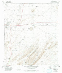
1983 Map of Marathon
USGS Topo · Published 1991About this map
Marathon serves as the central hub for this High Plains landscape, situated along the Southern Pacific railroad line. The settlement features essential community markers including a Cem, a Water Tank, and a High Sch, reflecting its role as a regional anchor. Beyond the town, the terrain is defined by a series of drainage draws and the prominent peaks of the Wood Hollow Mountains, which dominate the southeastern quadrant. Water access in this arid environment is meticulously documented through a network of windmills named for local families and locations, such as Wagner Windmill, Pulliam Windmill, and Coon Windmill. The infrastructure of the era is evident in the presence of a Landing Strip and Post Road, while the transition from plains to mountainous terrain is carved by features like Horse Run and Big Wood Hollow.
Find a feature on this map
37 named features on this map. Tap any name to fly to it.
Don’t see what you’re looking for? This feature index may not catch every label — zoom into the map to look around manually.
Map Details
Editions of this 1983 Marathon Map
2 editions found
Other maps of this area

1920 · Monument Spring
USGS Topo · 1:62,500

1920 · Marathon
USGS Topo · 1:62,500

1921 · Monument Spring
USGS Topo · 1:62,500

1921 · Marathon
USGS Topo · 1:62,500

1923 · Hess Canyon
USGS Topo · 1:62,500

1923 · Altuda
USGS Topo · 1:62,500

1954 · Fort Stockton
USGS Topo · 1:250,000

1958 · Fort Stockton
USGS Topo · 1:250,000
1967 · Horse Mountain
USGS Topo · 1:24,000

1973 · Fort Stockton
USGS Topo · 1:250,000