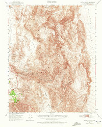
1951 Map of Marble Canyon
USGS Topo · Published 1972About this map
The Panamint Mountains dominate this high-desert landscape within the Death Valley National Monument, revealing a complex network of springs and canyons vital to early 20th-century prospecting. Remote water sources like Goldbelt Spring and Shorty Harris Spring mark the thin margin of survival for miners working the Ubehebe Mine or the Quakingbush Mine. The presence of Petroglyphs near Sand Flat provides a physical link to the area's ancient inhabitants, predating the arrival of the ranchers and miners who later named landmarks like Harris Hill. The terrain is defined by extreme elevation changes between Hidden Valley and Hunter Mountain, where a lone Jeep Trail provides the primary means of navigating the arid basins and steep ridges of Marble Canyon.
Find a feature on this map
22 named features on this map. Tap any name to fly to it.
Don’t see what you’re looking for? This feature index may not catch every label — zoom into the map to look around manually.
Map Details
Editions of this 1951 Marble Canyon Map
3 editions found
Other maps of this area

1908 · Ballarat
USGS Topo · 1:250,000

1913 · Ballarat
USGS Topo · 1:250,000

1948 · Death Valley
USGS Topo · 1:250,000

1950 · Darwin
USGS Topo · 1:62,500

1950 · Ubehebe Peak
USGS Topo · 1:62,500

1951 · Darwin
USGS Topo · 1:62,500

1951 · Ubehebe Peak
USGS Topo · 1:62,500

1951 · Panamint Butte
USGS Topo · 1:62,500

1951 · Marble Canyon
USGS Topo · 1:62,500

1952 · Stovepipe Wells
USGS Topo · 1:62,500