
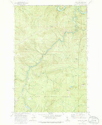
1969 Map of Marble Mountain
USGS Topo · Published 1973About this map
St Joe River carves through the heart of the St Joe National Forest in this late 1960s topographic study. The landscape is defined by the high elevations of Marble Mtn and Camelback Mtn, where numerous tributaries like Pocono Creek and Marble Creek feed the primary river system. Evidence of early 20th-century engineering is prominent along the river's path, specifically the CM St P & P railroad line. This route includes a notable Tunnel and passes through the small settlement of Pocono, positioned near Pocono Hill. The map detail shows a network of transit from another era, including several segments of Pack Trail and a Homestead Trail, reflecting the transition from traditional backcountry travel to more modern forest access via Jeep Trail and established Campground facilities near Donkey Creek.
Find a feature on this map
29 named features on this map. Tap any name to fly to it.
Don’t see what you’re looking for? This feature index may not catch every label — zoom into the map to look around manually.
Map Details
Editions of this 1969 Marble Mountain Map
2 editions found
Other maps of this area

1914 · Avery
USGS Topo · 1:125,000

1917 · Avery
USGS Topo · 1:125,000

1955 · Spokane
USGS Topo · 1:250,000

1956 · Wallace
USGS Topo · 1:250,000

1957 · Wallace
USGS Topo · 1:62,500

1957 · Calder
USGS Topo · 1:62,500

1958 · Spokane
USGS Topo · 1:250,000

1960 · Wallace
USGS Topo · 1:250,000

1969 · Grandmother Mtn
USGS Topo · 1:24,000
1969 · Hoyt Mountain
USGS Topo · 1:24,000