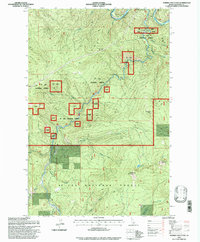
1995 Map of Marble Mountain
USGS Topo · Published 1997About this map
Marble Creek winds through the heart of this Idaho landscape, where the legacy of early 20th-century logging is preserved through unique industrial landmarks. The Presence of the Marble Creek Splash Dam and the Old RR Grade north of Pocono Hill points to a time when timber was moved by both river drives and rail through the St Joe National Forest. This 1995 revision, based on data updated in the early 1990s, documents the area's transition into a space for historical preservation and recreation, anchored by the Marble Creek Interpretive Center. The terrain is defined by high peaks such as Marble Mountain and Camelback Mountain, while drainage networks like Daveggio Creek and Shearer Creek feed into the northern flow of the St Joe River. Isolated water features like Theriault Lake and the long Homestead Trail offer a detailed look at the backcountry infrastructure of Shoshone County.
Find a feature on this map
23 named features on this map. Tap any name to fly to it.
Don’t see what you’re looking for? This feature index may not catch every label — zoom into the map to look around manually.
Map Details
Editions of this 1995 Marble Mountain Map
This is the sole edition of this map. No revisions or reprints were ever made.
Other maps of this area

1914 · Avery
USGS Topo · 1:125,000

1917 · Avery
USGS Topo · 1:125,000

1955 · Spokane
USGS Topo · 1:250,000

1956 · Wallace
USGS Topo · 1:250,000

1957 · Wallace
USGS Topo · 1:62,500

1957 · Calder
USGS Topo · 1:62,500

1958 · Spokane
USGS Topo · 1:250,000

1960 · Wallace
USGS Topo · 1:250,000

1969 · Marble Mountain
USGS Topo · 1:24,000

1969 · Grandmother Mtn
USGS Topo · 1:24,000