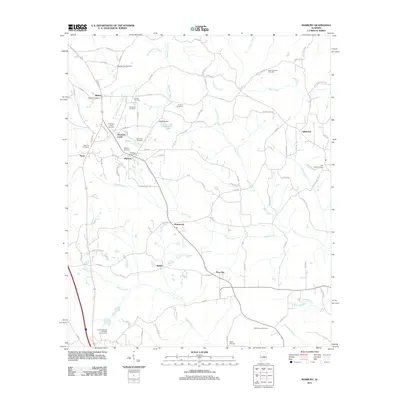
2011 Map of Marbury
USGS Topo · Published 2011About this map
Marbury and its surrounding communities are defined by a network of creeks and rural roads in central Alabama. The landscape is oriented around the Mountain Creek and Shoal Creek drainage basins, with development clustered along the corridor between Midway and Wadsworth. Local history is deeply rooted in the numerous family and community burial grounds, such as Canaan Cemetery, Saint Paul Cemetery, and the Morning Star Cemetery to the north.
Find a feature on this map
93 named features on this map. Tap any name to fly to it.
Don’t see what you’re looking for? This feature index may not catch every label — zoom into the map to look around manually.
Map Details
Editions of this 2011 Marbury Map
This is the sole edition of this map. No revisions or reprints were ever made.
Other maps of this area

1891 · Clanton
USGS Topo · 1:125,000

1901 · Wetumpka
USGS Topo · 1:125,000

1903 · Wetumpka
USGS Topo · 1:125,000

1953 · Montgomery
USGS Topo · 1:250,000

1956 · Montgomery
USGS Topo · 1:250,000

1957 · Montgomery
USGS Topo · 1:250,000

1959 · Billingsley
USGS Topo · 1:62,500

1959 · Elmore
USGS Topo · 1:62,500

1971 · Richville
USGS Topo · 1:24,000
1971 · Mitchell Dam
USGS Topo · 1:24,000