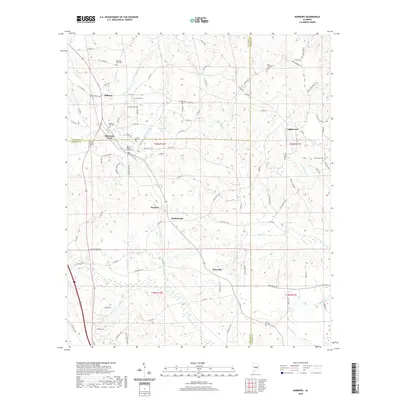
2020 Map of Marbury
USGS Topo · Published 2020About this map
Marbury and the surrounding central Alabama landscape are defined by a complex network of creeks and small settlements at the intersection of Autauga, Chilton, and Elmore counties. The terrain is deeply carved by waterways such as Shoal Cr, Mountain Cr, and Wolf Cr, which have historically dictated the placement of roads and homesteads. This map captures the area's rural character, where small communities like Wadsworth, Pine Flat, and Lightwood are anchored by long-standing local institutions. Numerous burial grounds, including Mountain Creek Cem and Saint Paul Cem, are scattered across the quadrangle, serving as vital markers for genealogical research. The presence of both the Marbury Church of God and Marbury Baptist Church highlights the town's role as a local spiritual and social hub. To the north, the cluster of settlements at Midway and Mountain Creek illustrates the persistent residential patterns of the region, while the drainage of Mortar Cr and Hurricane Br to the south shapes the agricultural and timbered reaches of the county line.
Find a feature on this map
107 named features on this map. Tap any name to fly to it.
Don’t see what you’re looking for? This feature index may not catch every label — zoom into the map to look around manually.
Map Details
Editions of this 2020 Marbury Map
This is the sole edition of this map. No revisions or reprints were ever made.
Other maps of this area

1891 · Clanton
USGS Topo · 1:125,000

1901 · Wetumpka
USGS Topo · 1:125,000

1903 · Wetumpka
USGS Topo · 1:125,000

1953 · Montgomery
USGS Topo · 1:250,000

1956 · Montgomery
USGS Topo · 1:250,000

1957 · Montgomery
USGS Topo · 1:250,000

1959 · Billingsley
USGS Topo · 1:62,500

1959 · Elmore
USGS Topo · 1:62,500

1971 · Richville
USGS Topo · 1:24,000
1971 · Mitchell Dam
USGS Topo · 1:24,000