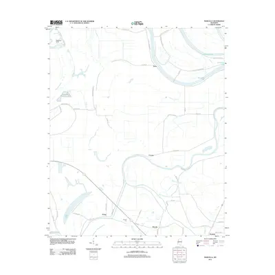
2012 Map of Marcella
USGS Topo · Published 2012About this map
Tchula Lake meanders across this alluvial landscape, defining the character of a region deeply shaped by the ancient movements of the Yazoo Basin's watercourses. Small agricultural communities such as Marcella, Choctaw, and Refuge are connected by a network of rural roads like Belmont Rd and Spruill Rd, illustrating the persistent settlement patterns of Holmes County. The presence of Marcella Cem and family-named landmarks like Palmatree Island provides specific points of interest for genealogists tracing local roots. Along the northern bends of the river, Horseshoe Lake and its surrounding plantation roads hint at the area's agricultural history. Further south, the terrain includes Boone's Deadening, a distinctive topographic feature near Eagle Lake, while Old Fannegusha Cr winds through the eastern portion of the sheet.
Find a feature on this map
45 named features on this map. Tap any name to fly to it.
Don’t see what you’re looking for? This feature index may not catch every label — zoom into the map to look around manually.
Map Details
Editions of this 2012 Marcella Map
This is the sole edition of this map. No revisions or reprints were ever made.
Other maps of this area

1940 · Seven Pines
USGS Topo · 1:62,500

1940 · Lexington
USGS Topo · 1:62,500

1940 · Mileston
USGS Topo · 1:62,500

1953 · Greenwood
USGS Topo · 1:250,000

1954 · Mileston
USGS Topo · 1:62,500

1956 · Greenwood
USGS Topo · 1:250,000

1957 · Lexington
USGS Topo · 1:62,500

1957 · Seven Pines
USGS Topo · 1:62,500

1958 · Seven Pines
USGS Topo · 1:62,500

1958 · Lexington
USGS Topo · 1:62,500