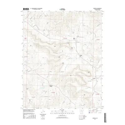
2017 Map of Marcella
USGS Topo · Published 2017About this map
Saint James and Pleasant Grove anchor this portion of Stone County, where the Ozark landscape is defined by deep hollows and prominent ridges. The geography is marked by significant elevation changes, from the heights of Irons Mtn and Miller Mtn down into the reaches of Knights Cove and Lickin Hollow. Water resources are abundant throughout the quadrangle, with Chalybeate Springs and the nearby Chalybeate Spring Cr suggesting the area's geological character. Local history and genealogy researchers will find several family-named landmarks and resting places, including the Kelly and Ford Cem near Davis Lake and the Dugan Cem further north. Small settlements like Marcella and Pine Hill are connected by a network of county roads such as Church Rd and Cajun Creek Rd, reflecting a dispersed rural community structure integrated with the local creek systems like Steam Mill Br and Massey Cr.
Find a feature on this map
106 named features on this map. Tap any name to fly to it.
Don’t see what you’re looking for? This feature index may not catch every label — zoom into the map to look around manually.
Map Details
Editions of this 2017 Marcella Map
This is the sole edition of this map. No revisions or reprints were ever made.
Other maps of this area

1890 · Batesville
USGS Topo · 1:125,000

1891 · Batesville
USGS Topo · 1:125,000

1892 · Mountain View
USGS Topo · 1:125,000

1894 · Mountain View
USGS Topo · 1:125,000

1942 · Bethesda
USGS Topo · 1:24,000

1942 · Almond
USGS Topo · 1:31,680

1942 · Mt Pleasant
USGS Topo · 1:31,680

1953 · Memphis
USGS Topo · 1:250,000

1956 · Memphis
USGS Topo · 1:250,000

1956 · Russellville
USGS Topo · 1:250,000