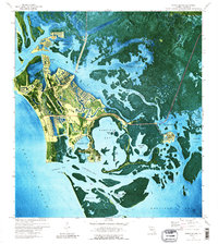
1973 Map of Marco Island
USGS Topo · Published 1989About this map
Marco and its neighboring island communities are captured here in a period of significant coastal transformation during the early 1970s. This orthophotomap combines traditional topographic data with aerial photography, revealing the intricate finger-canal developments that define the modern shoreline around Smokehouse Bay and Collier Bay. Amidst this rapid suburban expansion, older landmarks remain visible, including St Marks Ch, Barfield Sch, and the Old Railroad Grade cutting across the landscape. The intricate mangrove estuaries of the Ten Thousand Islands are shown in detail, with a complex network of waterways like the Big Marco River, Barfield Bay, and Blue Hill Creek separating Horrs Island and Kice Island from the mainland and the settled reaches of Goodland. The presence of the Toll Bridge at Bear Pt illustrates the growing connectivity of the Isles of Capri during this era.
Find a feature on this map
57 named features on this map. Tap any name to fly to it.
Don’t see what you’re looking for? This feature index may not catch every label — zoom into the map to look around manually.
Map Details
Editions of this 1973 Marco Island Map
3 editions found
Other maps of this area

1956 · Miami
USGS Topo · 1:250,000

1956 · West Palm Beach
USGS Topo · 1:250,000

1957 · West Palm Beach
USGS Topo · 1:250,000

1958 · West Palm Beach
USGS Topo · 1:250,000

1958 · Miami
USGS Topo · 1:250,000

1958 · Belle Meade
USGS Topo · 1:24,000

1958 · Naples South
USGS Topo · 1:24,000

1958 · Belle Meade SE
USGS Topo · 1:24,000

1973 · Cape Romano
USGS Topo · 1:24,000

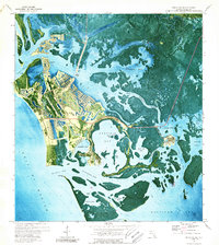
1973 · Marco Island
USGS Topo · 1:24,000