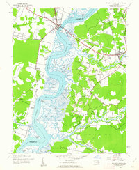
1942 Map of Mardela Springs
USGS Topo · Published 1962About this map
The Nanticoke River defines the tidal geography of this 1942 survey, serving as the border between Dorchester Co and Wicomico Co. Along its banks, the settlement of Vienna sits opposite Ferry Point, marking a historic crossing point for the region. The landscape is a network of water-dependent landmarks, from family-named landings like Lewis Landing and Jenkins Landing to the industrial utility of Campbells Wharf.
Find a feature on this map
65 named features on this map. Tap any name to fly to it.
Don’t see what you’re looking for? This feature index may not catch every label — zoom into the map to look around manually.
Map Details
Editions of this 1942 Mardela Springs Map
2 editions found
Other maps of this area

1901 · Salisbury
USGS Topo · 1:62,500

1903 · Nanticoke
USGS Topo · 1:62,500

1905 · Hurlock
USGS Topo · 1:62,500

1915 · Seaford
USGS Topo · 1:62,500

1942 · Wetipquin
USGS Topo · 1:24,000

1942 · Mardela Springs
USGS Topo · 1:24,000

1942 · Eden
USGS Topo · 1:24,000

1942 · Hebron
USGS Topo · 1:24,000
1942 · Nanticoke
USGS Topo · 1:24,000
1942 · Chicamacomico
USGS Topo · 1:24,000