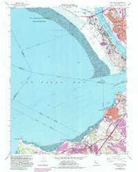
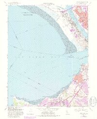
1959 Map of Mare Island
USGS Topo · Published 1985About this map
Mare Island Naval Reservation dominates this mid-century survey, anchoring a landscape where the industrial and military complex of Vallejo meets the waters of the Napa River and Carquinez Strait. The map documents the dense urban growth around Vallejo Heights and Federal Terrace School, as well as the wartime housing at Guadalcanal Village. Across the mudflats and the Pinole Shoal, the refinery and chemical corridor of Contra Costa County comes into focus, with settlements like Oleum, Rodeo, and Nitro strung along the Southern Pacific and Atchison Topeka and Santa Fe Railroad. This alignment of heavy industry and rail transport defines the southern shore, marked by features such as the Chemical Plant near Pinole and the Hercules Wharf. The inclusion of local landmarks like Old Hillside Cem and St Vincents Sch provides essential detail for tracing the social and institutional fabric of these waterfront communities.
Find a feature on this map
55 named features on this map. Tap any name to fly to it.
Don’t see what you’re looking for? This feature index may not catch every label — zoom into the map to look around manually.
Map Details
Editions of this 1959 Mare Island Map
5 editions found
Other maps of this area

1895 · San Francisco
USGS Topo · 1:62,500

1896 · Carquinez Strait
USGS Topo · 1:62,500

1897 · Concord
USGS Topo · 1:62,500

1898 · Karquines
USGS Topo · 1:62,500

1899 · San Francisco
USGS Topo · 1:62,500

1901 · Karquines
USGS Topo · 1:62,500

1902 · Napa
USGS Topo · 1:125,000

1915 · Concord
USGS Topo · 1:62,500

1915 · San Francisco
USGS Topo · 1:62,500

1916 · Mare Island
USGS Topo · 1:62,500