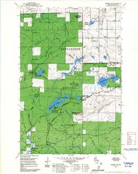
1967 Map of Marengo SE
USGS Topo · Published 1967About this map
Chequamegon National Forest dominates this northern Wisconsin landscape, characterized by a dense network of water bodies and primitive forest infrastructure. The upper reaches of the Brunsweiler River and Camp Six Creek drain the timbered interior, which is accessible via the North Country Trail and the local Memorial Drive. Fire detection and recreational management are central themes, evidenced by the presence of the Marengo Lookout and Mineral Lake Lookout. Fishermen and campers would have frequented the established Mineral Lake Campground and Lake Three Campground during this mid-century period. Several industrial features, including scattered Gravel Pits and a Quarry near English Lake, indicate the extraction of local materials for forest road development and maintenance within the Glidden Ranger District.
Find a feature on this map
33 named features on this map. Tap any name to fly to it.
Don’t see what you’re looking for? This feature index may not catch every label — zoom into the map to look around manually.
Map Details
Editions of this 1967 Marengo SE Map
This is the sole edition of this map. No revisions or reprints were ever made.
Other maps of this area

1942 · Glidden
USGS Topo · 1:48,000

1942 · Clam Lake
USGS Topo · 1:48,000

1942 · Mellen
USGS Topo · 1:48,000

1942 · Marengo
USGS Topo · 1:48,000

1945 · Marengo
USGS Topo · 1:48,000

1945 · Clam Lake
USGS Topo · 1:48,000

1945 · Glidden
USGS Topo · 1:48,000

1945 · Mellen
USGS Topo · 1:48,000

1953 · Ashland
USGS Topo · 1:250,000
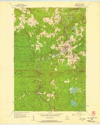
1956 · Mellen
USGS Topo · 1:24,000