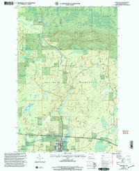
1999 Map of Marenisco
USGS Topo · Published 2004About this map
Marenisco serves as the focal point of this Upper Peninsula landscape, situated within the expansive Ottawa National Forest. The geography is defined by the winding course of the Presque Isle River, which transitions from the northern settlement of Ethelwood down toward the town center. The presence of Yondota Falls and multiple named watercourses like Kinnickinnie Creek and Marenisco Creek underscores the region's dense hydraulic network. Local industry and infrastructure are represented by a Gravel Pit and a prominent Pipeline, reflecting the utility and extraction activities common in this wooded interior. To the west, Wolf Mountain provides a significant vertical landmark, while smaller historical sites such as Theilers and the local Cemetary offer specific points of interest for those researching the genealogy and development of Gogebic County's rural communities at the turn of the millennium.
Find a feature on this map
25 named features on this map. Tap any name to fly to it.
Don’t see what you’re looking for? This feature index may not catch every label — zoom into the map to look around manually.
Map Details
Editions of this 1999 Marenisco Map
This is the sole edition of this map. No revisions or reprints were ever made.
Other maps of this area

1955 · Marenisco
USGS Topo · 1:62,500

1955 · Marenisco
USGS Topo · 1:24,000

1955 · Wakefield
USGS Topo · 1:62,500

1955 · Wakefield NE
USGS Topo · 1:24,000

1956 · Bergland
USGS Topo · 1:62,500

1956 · Thomaston
USGS Topo · 1:62,500

1958 · Iron River
USGS Topo · 1:250,000

1960 · Iron River
USGS Topo · 1:250,000

1961 · Iron River
USGS Topo · 1:250,000

1967 · Iron River
USGS Topo · 1:250,000